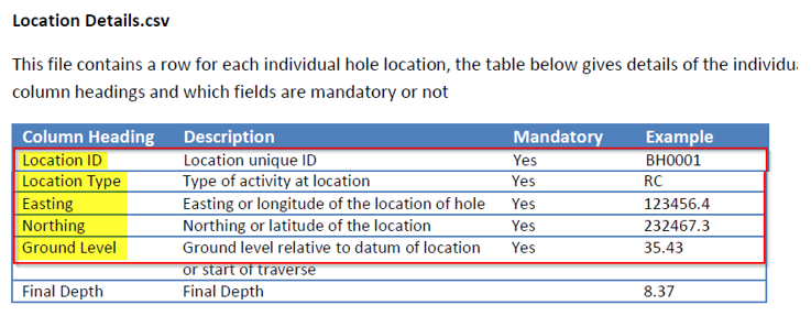
Hello everybody, because I been asked this question a lot in the last 2 weeks I decided to write a post about it... This is what you need to do if you want to work with CSV files to use the Geotechnical Module...
1. The .CSV files must keep that same name configuration
2. The heather of the files has to match exactly what the Geotechnical Module sample file has: name, space, and order.
3. You must have the mandatory fields for each file
If you take care of this everything will work as expected
skip to main |
skip to sidebar
![@Civil3DBTF @Civil3DBTF]()


Autodesk Certifications

BIM Manager @EDSA

- Tatiana Machado
- I am a Geotechnical Eng. interested in technology, an Adrenaline Junky and a Big Soccer Lover. My philosophy...Life is unexpected, so be prepare to be surprise!!!


![2017-06-16 09_41_50-Autodesk AutoCAD Civil 3D 2018 - [Drawing1.dwg].png 2017-06-16 09_41_50-Autodesk AutoCAD Civil 3D 2018 - [Drawing1.dwg].png](https://autodesk.i.lithium.com/t5/image/serverpage/image-id/368099i65D98A34D86004FE/image-size/large?v=1.0&px=705)
![2017-06-16 10_17_27-Autodesk AutoCAD Civil 3D 2018 - [Drawing1.dwg].png 2017-06-16 10_17_27-Autodesk AutoCAD Civil 3D 2018 - [Drawing1.dwg].png](https://autodesk.i.lithium.com/t5/image/serverpage/image-id/368102i043260569AE0ABFF/image-size/large?v=1.0&px=705)


