
Hello everybody.... Because not everything can be related just with work... this is something extra just for fun... enjoy the video created by Alan Becker, Animator Vs Animation...
Monday, April 28, 2008
Tuesday, April 1, 2008
Sneak peack about what is new in Civil 3D 2009!!!
Hi everybody... This is a presentation from Dominick Gallegos at Autodesk World Press Days 2008 in San Francisco, he is the Civil 3D Technical Marketing Manager of Autodesk for the Architecture Engineering and Construction (AEC) team; demonstrated the latest 2009 versions of AutoCAD Civil 3D.


Saturday, March 1, 2008
Recovering a drawing using the Map query build in Civil 3D!!!
Hello everybody!... Sometimes it is not possible to open a drawing because it is corrupt. In that case, you might attempt to recover the drawing using the RECOVER command, or by inserting it into another drawing using the INSERT command. However, when these methods are unsuccessful, you need another way to recover the drawing. So at this time I'm going to show you how you can use the Map Query functionality build in Civil 3D and LDT...
Tuesday, February 12, 2008
Autodesk Launches New Solutions for Building Information Modeling...!!!
Hello everybody... Good News!!!... Today Autodesk did a World Press Day event, where they announced updates to its comprehensive software solutions for building information modeling (BIM) including Revit Architecture, Revit Structure, Revit MEP, AutoCAD Civil 3D, and Autodesk NavisWorks. BIM is an integrated workflow built on coordinated, reliable information about a project from design through construction and into operations. By adopting BIM, architects, engineers, contractors and owners can easily create coordinated, digital design information and documentation; use that information to accurately predict performance, appearance and cost; and reliably deliver the project faster, more economically and with reduced environmental impact.
Autodesk is continually working to provide our customers with technology that guide them to achieve the competitive advantage and design innovation. Autodesk’s 3D modeling technologies are helping customers understand and improve the performance and operation of their designs before they are built.
AutoCAD Civil 3D 2009
AutoCAD Civil 3D 2009 enables the benefits of BIM for civil engineering, from surveying and design through to documentation submittal and the delivery of 3D models for GPS machine control during construction. Important new functions in AutoCAD Civil 3D 2009 include:
• A comprehensive stormwater hydraulics and hydrology solution for storm sewer design, watershed analysis, detention pond modeling, and culvert analysis.
• Complete survey functionality that allows users to directly import raw data; edit survey observations; and create points, figures, and surfaces that are directly integrated into the model to support the design process.
• Criteria-based road design that ensures local design requirements such as stopping and passing sight and headlight distances are being met.
• Easy to implement solution for sharing model data across project teams using standard AutoCAD xrefs and intelligent Civil 3D data shortcuts (without requiring Autodesk Vault).
... We are looking forward to see what this amazing solution can do for us now...
Autodesk is continually working to provide our customers with technology that guide them to achieve the competitive advantage and design innovation. Autodesk’s 3D modeling technologies are helping customers understand and improve the performance and operation of their designs before they are built.
AutoCAD Civil 3D 2009
AutoCAD Civil 3D 2009 enables the benefits of BIM for civil engineering, from surveying and design through to documentation submittal and the delivery of 3D models for GPS machine control during construction. Important new functions in AutoCAD Civil 3D 2009 include:
• A comprehensive stormwater hydraulics and hydrology solution for storm sewer design, watershed analysis, detention pond modeling, and culvert analysis.
• Complete survey functionality that allows users to directly import raw data; edit survey observations; and create points, figures, and surfaces that are directly integrated into the model to support the design process.
• Criteria-based road design that ensures local design requirements such as stopping and passing sight and headlight distances are being met.
• Easy to implement solution for sharing model data across project teams using standard AutoCAD xrefs and intelligent Civil 3D data shortcuts (without requiring Autodesk Vault).
... We are looking forward to see what this amazing solution can do for us now...
Friday, February 1, 2008
Changing Coordinate Systems with Map in Civil 3D!
Hi everybody... This time I would like to share with you how you can Transform from one Coordinate System to another using the Map 3D functionality build in Civil 3D and LDT.
Thursday, January 10, 2008
Plant Production Tool and Map Books!!!
Hi everybody... Last Friday Jan 4, I saw a really interesting webcast that Autodesk had for Civil 3D where Lucy Kuhns and Jerry Bartels did an excellent presentation about how the Plant Production Tool and the Map Books functionality that are built in Civil 3D 2008 could help you to improve your efficiency and productivity when you are creating a large set of sheets... so in case that you missed it, the section is recorded and abeilable for review...
Wednesday, January 2, 2008
Working with Survey Database…
Hi everybody… Happy New year to all of you!!!
Check this out…probably some of you had come across these questions; Can I change my working folder?? (and when I talk about working folder I mean the C:\Civil 3D Projects, where all my Survey Data is stored by default) and also How could I standardize my Survey User Settings so I don’t need to do it every time that I create a new one??... Well, here are some tips….
New survey databases automatically save to the current working folder (in the prospector tab, given that you are working on your Master View, right click on 'projects' and select 'set working folder').
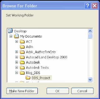 The only survey databases you can open are the ones located immediately under the current working folder.
Also you can set your Survey Database Settings on the same location …
First create a Survey Database with your common settings, like Units, Precision, Measurement Corrections, etc.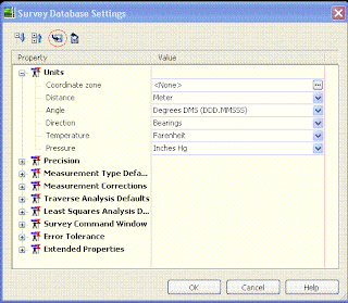 Then inside the Survey Database Settings window, click on the disk to export these setting to a file and select the location to save this file that probably you would like to name with your company name as a suggestion (I will recommend you to use the same location for everything like your working folder and in there you can include your Figure Prefix Database too, in this way you will have all your settings located on the same folder… but that is up to you…)
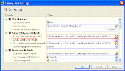
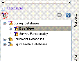 After you have done that go to your Survey User Settings and under Survey Database Defaults you can change the Survey database settings path to your new location and set the Survey Database Setting to the one that you just created… you also can do the same for your Figure Defaults just remember that your Figure style is associated with your Template… when you finish click OK… Now the next time you will create a new Survey Database it will be created with all your new settings…

Check this out…probably some of you had come across these questions; Can I change my working folder?? (and when I talk about working folder I mean the C:\Civil 3D Projects, where all my Survey Data is stored by default) and also How could I standardize my Survey User Settings so I don’t need to do it every time that I create a new one??... Well, here are some tips….
New survey databases automatically save to the current working folder (in the prospector tab, given that you are working on your Master View, right click on 'projects' and select 'set working folder').
 And browse for your new location that can be on your same computer or in a special place on your network.
The only survey databases you can open are the ones located immediately under the current working folder.Also you can set your Survey Database Settings on the same location …
First create a Survey Database with your common settings, like Units, Precision, Measurement Corrections, etc.
Then inside the Survey Database Settings window, click on the disk to export these setting to a file and select the location to save this file that probably you would like to name with your company name as a suggestion (I will recommend you to use the same location for everything like your working folder and in there you can include your Figure Prefix Database too, in this way you will have all your settings located on the same folder… but that is up to you…)After you have done that go to your Survey User Settings and under Survey Database Defaults you can change the Survey database settings path to your new location and set the Survey Database Setting to the one that you just created… you also can do the same for your Figure Defaults just remember that your Figure style is associated with your Template… when you finish click OK… Now the next time you will create a new Survey Database it will be created with all your new settings…
Subscribe to:
Posts (Atom)



 Posts
Posts


