Friday, July 14, 2017

How to edit the Curb and Gutter Component Road Dimensions in InfraWorks

I was asked if it was possible to edit the dimensions of the Curb and Gutter on the component road because those parameters show grayed out from within InfraWorks and the dimensions needed to be like a Type F Curve and Gutter, as shown below…
 
Here it is how you can make this work…
Go to:
C:\ProgramData\Autodesk\InfraWorks\LocalLibrary\Styles\ComponentDefinition
And look for the file called Curb & Gutter.ACItem (always make a copy of the original in case something goes wrong and rename it Curb & Gutter.ACItem.bak). 
Select the file, right click on it and go to Edit. This will open the file on the Notepad.
Please note that the parameters on this file are in meters, so conversion will be needed to resize this properly.
Once you are there, make the changes accordingly, this image will illustrate this better…
Each parameter is represented with a different color, the corresponding units are located at the left and the conversion to meters is shown between the brackets.
After making your changes, save the file, you will need to save it in a temporary location like the desktop and then move it back to the original location:
C:\ProgramData\Autodesk\InfraWorks\LocalLibrary\Styles\ComponentDefinition
Restart InfraWorks, open your model and check the changes you made…
** IMPORTANT ** Be aware once you make these changes you will modify the Curb and Gutter Road Component in InfraWorks, these changes will populate in all your models using the same component. So use this at your discretion.
Hope this will give you some ideas on how to modify other components or making your own component definition, but that may be a topic for another post… ;)
http://www.infrastructure-reimagined.com/


Tuesday, June 27, 2017

Civil 3D Geotechnical Module - How to work with CSV files...

Hello everybody, because I been asked this question a lot in the last 2 weeks I decided to write a post about it... This is what you need to do if you want to work with CSV files to use the Geotechnical Module...
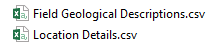
1. The .CSV files must keep that same name configuration
2017-06-16 10_16_50-Downloads.png
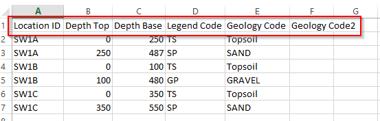
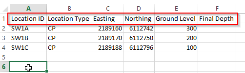
2. The heather of the files has to match exactly what the Geotechnical Module sample file has: name, space, and order.

2017-06-16 10_44_10-Field Geological Descriptions.csv - Excel.png
2017-06-16 09_45_37-HOLE.csv - Excel.png
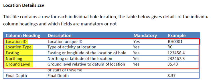
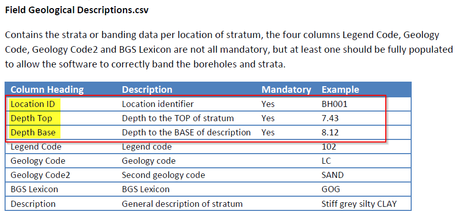
3. You must have the mandatory fields for each file
2017-06-16 10_27_52-manual-en.pdf - Adobe Acrobat Reader DC.png 2017-06-16 10_29_32-manual-en.pdf - Adobe Acrobat Reader DC.png
If you take care of this everything will work as expected
2017-06-16 09_41_50-Autodesk AutoCAD Civil 3D 2018 - [Drawing1.dwg].png 2017-06-16 10_17_27-Autodesk AutoCAD Civil 3D 2018 - [Drawing1.dwg].png

Thursday, June 22, 2017

Geolocation Online Maps Hotfix for ACAD Based Software's 2015 - 2018

Hi everyone... Autodesk just released a hotfix for the Geolocation Online Maps...
Microsoft® is ending support for version 7 of Bing® Maps on June 30th, 2017. This Hotfix will upgrade your version of Bing Maps to version 8 so that you can continue to use the Geolocation Online Map Data feature.
This Hotfix applies to all 32-bit and 64-bit publicly released versions of the following products (including Service Packs and Updates):
  • Autodesk AutoCAD 2015, Autodesk AutoCAD LT® 2015, and Autodesk AutoCAD 2015-based vertical products
  • Autodesk AutoCAD 2016, Autodesk AutoCAD LT 2016, and Autodesk AutoCAD 2016-based vertical products
  • Autodesk AutoCAD 2017, Autodesk AutoCAD LT 2017, and Autodesk AutoCAD 2017-based vertical products
  • Autodesk AutoCAD 2018, Autodesk AutoCAD LT 2018, and Autodesk AutoCAD 2018-based vertical products
Downolad and install the hotfix, please remember refear to the README file for detailed instructions.
Autodesk® AutoCAD® 2015-2018 Geolocation Online Map Hotfix

Thursday, June 8, 2017

Design Review 2017 Digital Signature issue

Hello everybody... Autodesk released a new version of Design Review, unfortunately, this new version doesn't allow you to add a digital signature to your DWF, for some government entities this is a must have, so if you updated to the new version you will need to rollback to the 2013 version in order to make it work.
Sadly it is no way to get this from the Autodesk website, so here is a link that you can get it from...
Autodesk Design Review 2013 installer

Thursday, May 4, 2017

InfraWorks Fence and Barrier Styles

Hi, all... This time I would like to share some InfraWorks Fence and Barrier Styles...
InfraWorks Fence and Barrier Style - Safety Fence

InfraWorks Fence and Barrier Style - Iron Fence

And here is a short video that shows how to create a fence and barrier style using a transparent PNG image...

Tuesday, May 2, 2017

InfraWorks Mobility Simulation

Hi all... This time I just want it to show you some cool studies that you can do with InfraWorks like Mobility Simulation...
Here is a site and parking done in Civil 3D with a Revit building, and this mobility simulation shows how people gets in and out the building and the parking lot and how traffic gets affected by this new site... Enjoy!

Monday, May 1, 2017

What is New in InfraWorks 2018.0 - Simplified Trees!

Hello, everybody... I just want it to share one of my favorite features of InfraWorks 2018.
If you work with a lot of trees on your model you will love this.... InfraWorks 2018 has now the ability to work with Simplified Trees... Disable realistic trees in your views...
Enabling and disabling realistic trees is a simple toggle switch within your view settings.
Working a simplified style of trees will consume few resources and will allow you to see objects behind the trees.
Take a look at this video courtesy of Autodesk Infraworks Youtube Channel:


@Civil3DBTF