
Hi everybody... This time I would like to share with you how you can Transform from one Coordinate System to another using the Map 3D functionality build in Civil 3D and LDT.
Friday, February 1, 2008
Thursday, January 10, 2008
Plant Production Tool and Map Books!!!
Hi everybody... Last Friday Jan 4, I saw a really interesting webcast that Autodesk had for Civil 3D where Lucy Kuhns and Jerry Bartels did an excellent presentation about how the Plant Production Tool and the Map Books functionality that are built in Civil 3D 2008 could help you to improve your efficiency and productivity when you are creating a large set of sheets... so in case that you missed it, the section is recorded and abeilable for review...


Wednesday, January 2, 2008
Working with Survey Database…
Hi everybody… Happy New year to all of you!!!
Check this out…probably some of you had come across these questions; Can I change my working folder?? (and when I talk about working folder I mean the C:\Civil 3D Projects, where all my Survey Data is stored by default) and also How could I standardize my Survey User Settings so I don’t need to do it every time that I create a new one??... Well, here are some tips….
New survey databases automatically save to the current working folder (in the prospector tab, given that you are working on your Master View, right click on 'projects' and select 'set working folder').
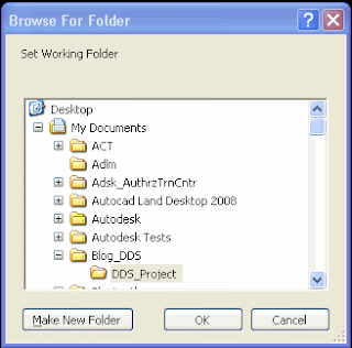 The only survey databases you can open are the ones located immediately under the current working folder.
Also you can set your Survey Database Settings on the same location …
First create a Survey Database with your common settings, like Units, Precision, Measurement Corrections, etc.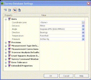 Then inside the Survey Database Settings window, click on the disk to export these setting to a file and select the location to save this file that probably you would like to name with your company name as a suggestion (I will recommend you to use the same location for everything like your working folder and in there you can include your Figure Prefix Database too, in this way you will have all your settings located on the same folder… but that is up to you…)
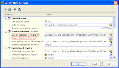
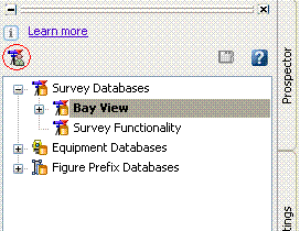 After you have done that go to your Survey User Settings and under Survey Database Defaults you can change the Survey database settings path to your new location and set the Survey Database Setting to the one that you just created… you also can do the same for your Figure Defaults just remember that your Figure style is associated with your Template… when you finish click OK… Now the next time you will create a new Survey Database it will be created with all your new settings…

Check this out…probably some of you had come across these questions; Can I change my working folder?? (and when I talk about working folder I mean the C:\Civil 3D Projects, where all my Survey Data is stored by default) and also How could I standardize my Survey User Settings so I don’t need to do it every time that I create a new one??... Well, here are some tips….
New survey databases automatically save to the current working folder (in the prospector tab, given that you are working on your Master View, right click on 'projects' and select 'set working folder').
 And browse for your new location that can be on your same computer or in a special place on your network.
The only survey databases you can open are the ones located immediately under the current working folder.Also you can set your Survey Database Settings on the same location …
First create a Survey Database with your common settings, like Units, Precision, Measurement Corrections, etc.
Then inside the Survey Database Settings window, click on the disk to export these setting to a file and select the location to save this file that probably you would like to name with your company name as a suggestion (I will recommend you to use the same location for everything like your working folder and in there you can include your Figure Prefix Database too, in this way you will have all your settings located on the same folder… but that is up to you…)After you have done that go to your Survey User Settings and under Survey Database Defaults you can change the Survey database settings path to your new location and set the Survey Database Setting to the one that you just created… you also can do the same for your Figure Defaults just remember that your Figure style is associated with your Template… when you finish click OK… Now the next time you will create a new Survey Database it will be created with all your new settings…
Thursday, December 13, 2007
Working with LDT Data in Civil 3D...!!!
Hi everybody... I think that this is a really cool tip... enjoy the video...
Monday, December 10, 2007
New Stormwater Design and Analysis Extensions for Civil 3D!!!
Hi everyone.... Autodesk is continuously coming out with solutions and applications to improve Civil 3D 2008. At this time, Autodesk recently concluded the acquisition of Intelisolve’s Business. Intelisolve is a highly respected provider of Hydraulics and Hydrology Design and Analysis Software for Civil Engineering. This acquisition adds important technology to our civil engineering solution and will help our customers address a critical part of their workflow.
The acquired technology will be delivered as three extensions for AutoCAD Civil 3D subscribers:
- Hydraflow Storm Sewers Extension for storm sewer analysis and design.
- Hydraflow Hydrographs Extension for pond design.
- Hydraflow Express Extension for culvert, channel, and inlet analysis.
You can find out some highlights in AutoCAD Civil 3D Stormwater Website to provide details on the functionality of the extensions.
The three extensions are available for download by AutoCAD Civil 3D 2008 Subscription Users from the Autodesk Subscription Center.
The acquired technology will be delivered as three extensions for AutoCAD Civil 3D subscribers:
- Hydraflow Storm Sewers Extension for storm sewer analysis and design.
- Hydraflow Hydrographs Extension for pond design.
- Hydraflow Express Extension for culvert, channel, and inlet analysis.
You can find out some highlights in AutoCAD Civil 3D Stormwater Website to provide details on the functionality of the extensions.
The three extensions are available for download by AutoCAD Civil 3D 2008 Subscription Users from the Autodesk Subscription Center.
Wednesday, December 5, 2007
Probably this could help you!!!
Hi Everybody... These are some videos that I hope they will help you to work or figure out some things...
Survey and Civil 3D - Working with Survey Link
Survey and Civil 3D - Working with Survey Link
Creating a Distance with crows feet Label
Thursday, November 1, 2007
Survey Equipment Partners and More…
Autodesk works closely with a number of suppliers of survey equipment as well as developers of software add-ons for Civil 3D. (To go to the links please click on the logos)

Leica X-change provides a seamless link between Leica System 1200 surveying equipment and the AutoCAD Civil 3D environment.
 Trimble Link for AutoCAD Civil 3D enables you to transfer survey and design data between the Civil 3D database and Trimble field systems including the TSC1, TSCe, ACU Controller, Trimble CU Controller, Geodimeter CU600, and supported Nikon instruments. It further supports the use of Trimble site controller systems.

Carlson Connect is an add-on to AutoCAD Civil 3D 2008 that offers a collection of routines for transferring and converting data between Civil 3D 2008 and several popular data collectors. Carlson Connect runs inside Civil 3D 2008 and uses the current project data and design environment. Carlson Connect is a free utility to any Civil 3D 2008 user and can be downloaded.
Find more information about the availability of trird-party applications compatible with AutoCAD Civil 3D software in Partner Products & Services .
Leica X-change provides a seamless link between Leica System 1200 surveying equipment and the AutoCAD Civil 3D environment.
Trimble Link for AutoCAD Civil 3D enables you to transfer survey and design data between the Civil 3D database and Trimble field systems including the TSC1, TSCe, ACU Controller, Trimble CU Controller, Geodimeter CU600, and supported Nikon instruments. It further supports the use of Trimble site controller systems. Carlson Connect is an add-on to AutoCAD Civil 3D 2008 that offers a collection of routines for transferring and converting data between Civil 3D 2008 and several popular data collectors. Carlson Connect runs inside Civil 3D 2008 and uses the current project data and design environment. Carlson Connect is a free utility to any Civil 3D 2008 user and can be downloaded.
Find more information about the availability of trird-party applications compatible with AutoCAD Civil 3D software in Partner Products & Services .
Subscribe to:
Posts (Atom)



 Posts
Posts


