Wednesday, July 26, 2017

AutoCAD: The License manager is not functioning or is improperly installed (Part 3)

Recently I was in an installation support call with a customer that was getting the above message after installing AutoCAD 2018...
I tried everything listed in these articles:
      None of those things worked. 

      Finally what it works was, completely removing C++ from the machine through the Control Panel and installing them again from the software installation folder (my case BDSP 2018):

      C:\Autodesk\(Autodesk_Software)\3rdParty\x86\VCRedist  
      Install each one of them top to bottom 
      C:\Autodesk\(Autodesk_Software)\3rdParty\x64\VCRedist
      Install each one of them top to bottom

      After that everything worked as expected.
      Thank you Sebastian Guevara from the Autodesk Installation & Licensing Department

      Monday, July 24, 2017

      Working with SketchUp Vs FormIt file types and InfraWorks...

      Have you ever wonder why if you import an FBX file from any of the available sources like SketchUp, FormIt, any AutoCAD Based software, Revit, Navis to name some of them in InfraWorks regardless of the file units the results are all over the place, sometimes it works, sometimes it doesn't, but must of the time the object or objects are in the wrong size...???? 
      Well, I took the time to do some comparisons between an export from AutoCAD, FormIt, and SketchUp to the most used file formats Collada (.DAE), .FBX and .OBJ and the way they behave when you import them in InfraWorks as a 3D Models or if you create a 3D Model Style with the same file types...
      I worked with a 10-foot Cube, simple and symmetrical geometry for testing porpuses.
      Here are my findings...
      If you import the same Cube created and exported out from the above-mentioned software into InfraWorks and configure the files as a 3D Models, this is what you get...
      Now using the same files side by side as 3D Models vs 3D Model Styles:
      - Exported from AutoCAD C3D as an FBX
      - Exported from SketchUp and FormIt as an FBX
       - Exported from SketchUp as a Collada (.DAE)
       - Exported from FormIt as a Collada (.DAE)...
      Please be aware that I am ONLY making a comparason on the behavior of the objects size wise, none of the examples above include textures, that is another subject ... ;)
      Hope this will help you to get a better picture of how to work with the different file types and the software that create them...
      Cheers!

      Friday, July 14, 2017

      How to edit the Curb and Gutter Component Road Dimensions in InfraWorks

      I was asked if it was possible to edit the dimensions of the Curb and Gutter on the component road because those parameters show grayed out from within InfraWorks and the dimensions needed to be like a Type F Curve and Gutter, as shown below…
       
      Here it is how you can make this work…
      Go to:
      C:\ProgramData\Autodesk\InfraWorks\LocalLibrary\Styles\ComponentDefinition
      And look for the file called Curb & Gutter.ACItem (always make a copy of the original in case something goes wrong and rename it Curb & Gutter.ACItem.bak). 
      Select the file, right click on it and go to Edit. This will open the file on the Notepad.
      Please note that the parameters on this file are in meters, so conversion will be needed to resize this properly.
      Once you are there, make the changes accordingly, this image will illustrate this better…
      Each parameter is represented with a different color, the corresponding units are located at the left and the conversion to meters is shown between the brackets.
      After making your changes, save the file, you will need to save it in a temporary location like the desktop and then move it back to the original location:
      C:\ProgramData\Autodesk\InfraWorks\LocalLibrary\Styles\ComponentDefinition
      Restart InfraWorks, open your model and check the changes you made…
      ** IMPORTANT ** Be aware once you make these changes you will modify the Curb and Gutter Road Component in InfraWorks, these changes will populate in all your models using the same component. So use this at your discretion.
      Hope this will give you some ideas on how to modify other components or making your own component definition, but that may be a topic for another post… ;)
      http://www.infrastructure-reimagined.com/


      Tuesday, June 27, 2017

      Civil 3D Geotechnical Module - How to work with CSV files...

      Hello everybody, because I been asked this question a lot in the last 2 weeks I decided to write a post about it... This is what you need to do if you want to work with CSV files to use the Geotechnical Module...
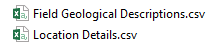
      1. The .CSV files must keep that same name configuration
      2017-06-16 10_16_50-Downloads.png
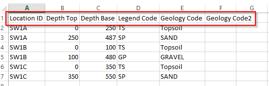
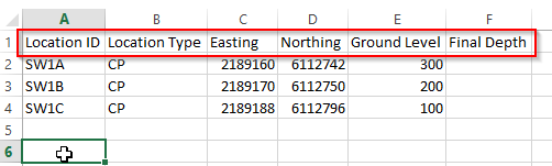
      2. The heather of the files has to match exactly what the Geotechnical Module sample file has: name, space, and order.

      2017-06-16 10_44_10-Field Geological Descriptions.csv - Excel.png
      2017-06-16 09_45_37-HOLE.csv - Excel.png
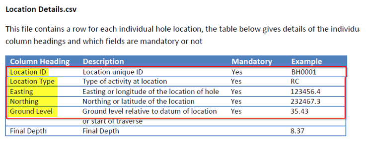
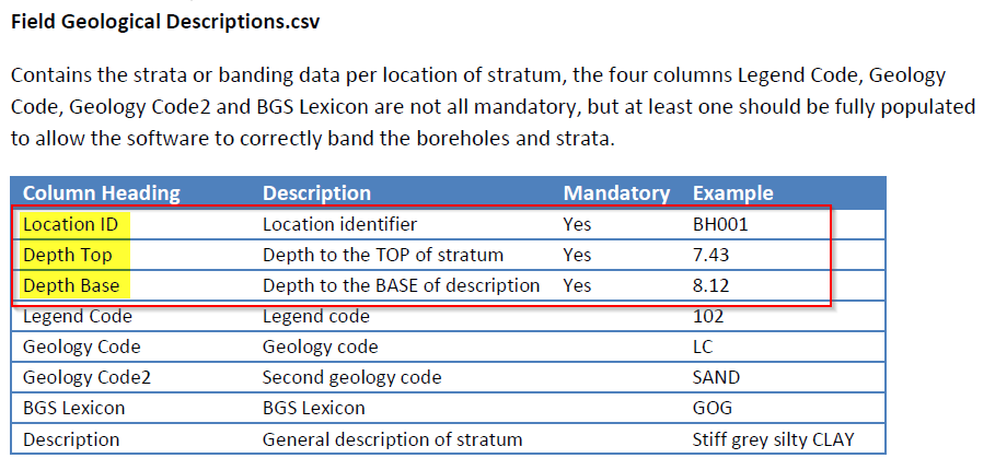
      3. You must have the mandatory fields for each file
      2017-06-16 10_27_52-manual-en.pdf - Adobe Acrobat Reader DC.png 2017-06-16 10_29_32-manual-en.pdf - Adobe Acrobat Reader DC.png
      If you take care of this everything will work as expected
      2017-06-16 09_41_50-Autodesk AutoCAD Civil 3D 2018 - [Drawing1.dwg].png 2017-06-16 10_17_27-Autodesk AutoCAD Civil 3D 2018 - [Drawing1.dwg].png

      Thursday, June 22, 2017

      Geolocation Online Maps Hotfix for ACAD Based Software's 2015 - 2018

      Hi everyone... Autodesk just released a hotfix for the Geolocation Online Maps...
      Microsoft® is ending support for version 7 of Bing® Maps on June 30th, 2017. This Hotfix will upgrade your version of Bing Maps to version 8 so that you can continue to use the Geolocation Online Map Data feature.
      This Hotfix applies to all 32-bit and 64-bit publicly released versions of the following products (including Service Packs and Updates):
      • Autodesk AutoCAD 2015, Autodesk AutoCAD LT® 2015, and Autodesk AutoCAD 2015-based vertical products
      • Autodesk AutoCAD 2016, Autodesk AutoCAD LT 2016, and Autodesk AutoCAD 2016-based vertical products
      • Autodesk AutoCAD 2017, Autodesk AutoCAD LT 2017, and Autodesk AutoCAD 2017-based vertical products
      • Autodesk AutoCAD 2018, Autodesk AutoCAD LT 2018, and Autodesk AutoCAD 2018-based vertical products
      Downolad and install the hotfix, please remember refear to the README file for detailed instructions.
      Autodesk® AutoCAD® 2015-2018 Geolocation Online Map Hotfix

      Thursday, June 8, 2017

      Design Review 2017 Digital Signature issue

      Hello everybody... Autodesk released a new version of Design Review, unfortunately, this new version doesn't allow you to add a digital signature to your DWF, for some government entities this is a must have, so if you updated to the new version you will need to rollback to the 2013 version in order to make it work.
      Sadly it is no way to get this from the Autodesk website, so here is a link that you can get it from...
      Autodesk Design Review 2013 installer

      Thursday, May 4, 2017

      InfraWorks Fence and Barrier Styles

      Hi, all... This time I would like to share some InfraWorks Fence and Barrier Styles...
      InfraWorks Fence and Barrier Style - Safety Fence

      InfraWorks Fence and Barrier Style - Iron Fence

      And here is a short video that shows how to create a fence and barrier style using a transparent PNG image...

      Tuesday, May 2, 2017

      InfraWorks Mobility Simulation

      Hi all... This time I just want it to show you some cool studies that you can do with InfraWorks like Mobility Simulation...
      Here is a site and parking done in Civil 3D with a Revit building, and this mobility simulation shows how people gets in and out the building and the parking lot and how traffic gets affected by this new site... Enjoy!

      Monday, May 1, 2017

      What is New in InfraWorks 2018.0 - Simplified Trees!

      Hello, everybody... I just want it to share one of my favorite features of InfraWorks 2018.
      If you work with a lot of trees on your model you will love this.... InfraWorks 2018 has now the ability to work with Simplified Trees... Disable realistic trees in your views...
      Enabling and disabling realistic trees is a simple toggle switch within your view settings.
      Working a simplified style of trees will consume few resources and will allow you to see objects behind the trees.
      Take a look at this video courtesy of Autodesk Infraworks Youtube Channel:


      Tuesday, April 25, 2017

      What is New in AutoCAD Civil 3D 2018 - Interoperability Between Versions

      Hello everyone… With the introduction of a New File Format and Feature Format on Autodesk® AutoCAD® Civil 3D® 2018 Interoperability Between Versions is, as usual, a hot topic…
      Here are a couple of things you need to know…
      Objects in a drawing saved in AutoCAD Civil 3D 2018 are available only as proxies when the drawing is opened in a prior version of the software.
      Within AutoCAD Civil 3D 2018, set the PROXYGRAPHICS drawing setting to 1 to save the graphics with the drawing, otherwise, a bounding box is displayed where the object is located when the drawing is opened in a prior version of the software.
      Hope this will help!

      Monday, April 25, 2016

      Microsoft "Run as administrator" and Autodesk software issue

      Hi everyone... In previous versions of Windows, you had to use an administrator account to do certain things, such as changing system settings or installing software. If you were logged on as a limited user, the Run as command eliminated the need to log off and then log back on as an administrator.

      Since Windows 7, the Run as command has been changed to Run as administrator.

      In Windows 8.1 and Windows 10, it seems that something changed on the permission protocols of Windows and if you launch your Autodesk software with " Run as administrator " you will run into some issues.

      - The first one of them is the inability to Drag and Drop files into the application because this function is prohibit, like SHP files to name some of them in AutoCAD Civil 3D or Map 3D or any type of drag and drop data in InfraWorks 360. (Video)

      - The second one is the inability to access your Mapped Network Drives from within the software, because they don't show under the Microsoft Explorer tree. (Video)

      Here is the link to my original post from the Autodesk Knowledge Network

      Wednesday, February 24, 2016

      How to assign Coordinate System to a Revit Model using Autodesk Shared Reference Point

      Hello everyone... This time I would like to share how using Autodesk Shared Reference Point for Civil 3D and Revit, you will be able to assign true coordinate system to your Revit Model and use that information to locate your building on a real content information model in InfraWorks 360 as well.
      The Autodesk® Shared Reference Point extension provides functionality to export known points and elevation from AutoCAD Civil 3D to an external file, in which Revit can import and setup a ‘Shared Coordinate System’. This enables the collaboration of exported RVT, DWG and NWC files back to AutoCAD Civil 3D and to coordinate models in Autodesk Navisworks.
      Key Features of this Extension
      Autodesk® Shared Reference Point consists of the following features:
      • Two individual installations for AutoCAD Civil 3D and Revit
      • Export coordinates and elevation from AutoCAD Civil 3D to external .xml file
      • Import .xml into Revit based on same known positions and create a ‘Shared Coordinate System’

      Friday, January 29, 2016

      "There was a problem sending the command to the program" AutoCAD error

      Hi there.... This time I will like to show you how to fix the very annoying Microsoft association file error message.
      The issue is that when you double click in any DWG file you get this error message:
      Here is how to fix it:
      1. Go to:
      C:\Program Files\Common Files\Autodesk Shared\AcShellEx
      2. Select the file call AcLauncher.exe and right click on it.
      3. Go to Properties -> Compatibility Tab -> Change settings for all users.
      4. And select Run this program as an administrator, click Apply and OK until you exit the Properties window.
       5. Then select one of your DWG files, right click on it and go to Open with -> Choose another app
      6. Select the AutoCAD DWG Launcher and make sure that you the box Always use this app to open .dwg files and click OK.
      After this you should be able to open any DWG file double clicking on it without getting any error message.

      Tuesday, September 8, 2015

      AutoCAD 2015/2016 Freezing Up…

      We had couple of customers calling about their AutoCAD’s freezing up at multiple times randomly during the day; after trying multiples things, here are the changes we did to make it work:
      1. Autodesk software needs full permission to:
       

      Registry Entries:
      HKEY_CURRENT_USER\SOFTWARE\AUTODESK

      HKEY_LOCAL_MACHINE\SOFTWARE\AUTODESK
       

      Folders:
      The folder the program was installed in, such as:
      C:\program files\Autodesk\AutoCAD 201x (for example)
       

      Windows 7 / Windows 8 / Windows 10:
      C:\Users\All Users\Autodesk
      C:\Users\\AppData\Local\Autodesk
      C:\Users\\AppData\Roaming\Autodesk
      C:\Program Files\Common Files\Autodesk Shared
       

      2. Disable “Show Home Base on Startup” in the Registry Editor:
      HKEY_CURRENT_USER\Software\Autodesk\DirectConnect\RegistryVersion20.0\System\Preferences\File

      Look for: 
      ShowHomeBaseOnStartup and change it to cero (0)

      Wednesday, September 2, 2015

      Whats New in InfraWorks 360 - September 2015 release?

      InfraWorks 360 2016.3 has been released... The September release include cool new features and enhancements.
      Here is an update overview video courtesy of  Eric Chappell, Autodesk Community Evangelist for InfraWorks 360:
       
      You can find more information on the Autodesk InfraWorks 360 Video Library

      Thursday, July 30, 2015

      Autodesk Windows 10 Support

      It is very important to know that Windows 10 it is NOT Supported by any Autodesk software yet. This may change as Autodesk release any specific service pack to address this.
      As instated on the Autodesk Knowledge Network:

      Windows 10 support for Autodesk products


      Issue:

      You want to know which Autodesk products are supported on Microsoft® Windows® 10.
      Note: Unless indicated otherwise, this information applies to only the 2016–2013 versions of all Autodesk products. Autodesk product versions of 2012 and earlier are no longer supported and are not included in considerations of Windows 10 compatibility.

      Solution:

      Windows 10 is not yet an officially supported operating system across the Autodesk product line. Autodesk intends to support many of our key products on Windows 10 and will add products to the list of products supported on Windows 10 as updates and future versions are released. Product Support will assist customers who have issues with current Autodesk products running on Windows 10.
      Note: This article will be updated as new Windows 10 compatibility information becomes available.

      Autodesk 2016 Software’s Supported OS
      OS
      32-bit
      64-bit
      Windows® 8.1
      Windows 8.1,
      Windows 8.1 Pro,
      Windows 8.1 Enterprise
      Windows 8.1,
      Windows 8.1 Pro,
      Windows 8.1 Enterprise
      Windows® 8
      Windows 8,
      Windows 8 Pro,
      Windows 8 Enterprise
      Windows 8,
      Windows 8 Pro,
      Windows 8 Enterprise
      Windows® 7
      Windows 7 Enterprise,
      Windows 7 Ultimate,
      Windows 7 Professional,
      Windows 7 Home Premium
      Windows 7 Enterprise,
      Windows 7 Ultimate,
      Windows 7 Professional,
      Windows 7 Home Premium
      Autodesk 2015 Software’s Supported OS
      OS
      32-bit
      64-bit
      Windows® 8.1
      Windows 8.1,
      Windows 8.1 Pro,
      Windows 8.1 Enterprise
      Windows 8.1,
      Windows 8.1 Pro,
      Windows 8.1 Enterprise
      Windows® 8
      Windows 8,
      Windows 8 Pro,
      Windows 8 Enterprise
      Windows 8,
      Windows 8 Pro,
      Windows 8 Enterprise
      Windows® 7
      Windows 7 Enterprise,
      Windows 7 Ultimate,
      Windows 7 Professional,
      Windows 7 Home Premium
      Windows 7 Enterprise,
      Windows 7 Ultimate,
      Windows 7 Professional,
      Windows 7 Home Premium
      Autodesk 2014 Software’s Supported OS
      OS
      32-bit
      64-bit
      Windows® 8
      Windows 8,
      Windows 8 Enterprise,
      Windows 8 Professional
      Windows 8,
      Windows 8 Enterprise,
      Windows 8 Professional
      Windows® 7
      Windows 7 Enterprise,
      Windows 7 Ultimate,
      Windows 7 Professional,
      Windows 7 Home Premium
      Windows 7 Enterprise,
      Windows 7 Ultimate,
      Windows 7 Professional,
      Windows 7 Home Premium
      Windows® XP
      Windows XP Professional,
      Windows XP Home Edition
      (SP3 or later)
      Windows XP Professional x64 Edition
      (SP2 or later)
      Autodesk 2013 Software’s Supported OS
      OS
      32-bit
      64-bit
      Windows® 8
      Standard,
      Professional,
      Enterprise
      (Requires AutoCAD or AutoCAD LT 2013 SP2)
      Standard,
      Professional,
      Enterprise
      (Requires AutoCAD or AutoCAD LT 2013 SP2)
      Windows® 7
      Enterprise,
      Ultimate,
      Professional,
      Home Premium
      Enterprise,
      Ultimate,
      Professional,
      Home Premium
      Windows® XP
      Professional,
      Home Edition
      (SP3 or later)
      Professional x64 Edition
      (SP2 or later)
      Just so you know Microsoft Fix It doesn’t work with Windows 10.
      Please Upgrade “Cautiously”.


      @Civil3DBTF