


 So go ahead, take your time and see for yourself all the effort and information that Autodesk has put together and that is available to us... Don't be afraid... The Technology is moving to the future and we are moving alone with it... Let's experience it before it's real!!!
 • Immediate Diagnostic Feedback - Whether or not you pass the exam, you receive immediate feedback on areas to improve your Autodesk application skills. Your score report with feedback is available at any time through your Autodesk Online system profile. http://autodesk.starttest.com/.
• Listing on Autodesk in the Certified Users Database - Once certified, you can choose to have your contact information and certifications listed in Autodesk’s publically available database. This is an excellent way to immediately demonstrate your certification status to prospective employers.
AutoCAD Civil 3D 2009 Certification Guide
Autodesk Authorized Certification Center Search
... So what are you waiting for??... Lest do it!!!... On the Selection Tab, under Selection Preview, uncheck the option When no command is active, doing this the software will not highlight every element when you are moving your crosshair over the objects on your drawing.
  Now on the Open and Save Tab, under File Safety Precautions, uncheck the Automatic save option… I know you're probably thinking … “NO, I CAN’T DO THAT, SHE IS CRAZY”…. Well, I guess that if you are afraid to do it, you could set it up to a big number like every 60 mins, what happen is actually the software manage to do the auto save when another command is running, if your drawing is to big this could crash your application.
 Another tip: In the new 2009 software, Autodesk has incorporated the Quick Properties option under the Status Bar, this option is really useful, because it allow us to display the properties of an object like: type, color, layer, linetype, and others when you select or get on top of the object. Unfortunately this is a dynamic tool that uses some memory because it is constantly looking for information, my recommendation is to turn it off.
 And last but not least, for those of us that like to work with the Layer Properties Manager opened, I don’t know if you have noticed that in 2009 there is not an Apply or OK button anymore, what this means is that actually the Layer Manager is Dynamic, every change that you make will take place automatically, so if you are no using it, it is better to keep it closed , because if it’s always open it’s going to check the layers to see if something have changed and this will slow down your computer a lot… Hopefully this suggestions will help you!!!

 The Second of them, is a little marker that looks like a flower that probably you have seen in your drawings, that rescale by itself every time that you do a zoom... if you have seen it, yes it can make you crazy... This little marker is called Geographic Marker and what happen is that by default Civil 3D 2009 has it setup to be in your drawing once you assign Coordinate System to it... How can you make it disappear? simple, just type GEOMARKERVISIBILITY on your command line and change the value for <0>...
 Controls the visibility of geographic markers.


Hi everybody... This time I would like to share with you how you can Transform from one Coordinate System to another using the Map 3D functionality build in Civil 3D and LDT.
 And browse for your new location that can be on your same computer or in a special place on your network.
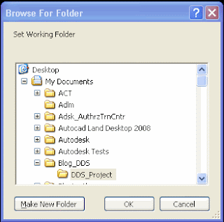 The only survey databases you can open are the ones located immediately under the current working folder.
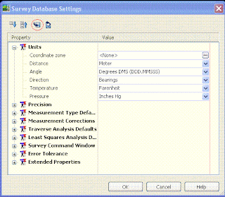 Then inside the Survey Database Settings window, click on the disk to export these setting to a file and select the location to save this file that probably you would like to name with your company name as a suggestion (I will recommend you to use the same location for everything like your working folder and in there you can include your Figure Prefix Database too, in this way you will have all your settings located on the same folder… but that is up to you…)
 After you have done that go to your Survey User Settings and under Survey Database Defaults you can change the Survey database settings path to your new location and set the Survey Database Setting to the one that you just created… you also can do the same for your Figure Defaults just remember that your Figure style is associated with your Template… when you finish click OK… Now the next time you will create a new Survey Database it will be created with all your new settings…
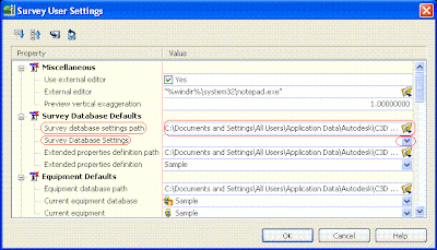


